When you click on links to various merchants on this site and make a purchase, this can result in this site earning a commission. Affiliate programs and affiliations include, but are not limited to, the eBay Partner Network.
Whsmith.co.uk

Historical Images Ltd A County Of Sussex 1611 - 1836 - Fold Up Map That Features A Collection Of Four Historic Maps, John Speed'S County Map 1611, Johan Blaeu'S County Map Of 1648, Thomas Moules County Map Of 1836 And A Pl

Whsmith.co.uk

Historical Images Ltd A County Of Sussex 1611 - 1836 - Fold Up Map That Features A Collection Of Four Historic Maps, John Speed'S County Map 1611, Johan Blaeu'S County Map Of 1648, Thomas Moules County Map Of 1836 And A Pl

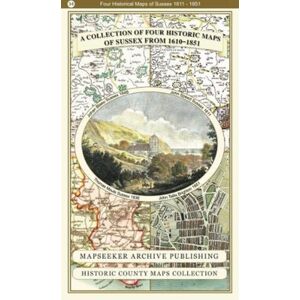
This folded map (890mm x 1000mm when unfolded) is an ideal souvenir for tourists to Sussex and also a valuable reference resource for local and family history research.It includes 4 Historic maps of Sussex, John Speed's County Map of Sussex 1610, Johan Blaeu's County Map of Sussex 1648,Thomas Moule's County Map of Sussex 1836 and a detailed Plan of Brighton by John Tallis 1851.All the maps have been meticulously re-produced from antique originals and printed on 90 gsm "Progeo" paper which was specially developed as a map paper.It has high opacity to help reduce show through and a cross grain giving it greater durability to as the map is being folded.

from £18.39
Seller: Whsmith.co.uk

Latest products

By Continuing to use this site you confirm, your consent to us and our partners collecting data from you, using cookies to serve personalised ads, tailoring content to you and optimising the site itself. You can learn more about the collection and use of your data and to change your preferences at any time by seeing our Privacy Policy and Cookie Policy.
Accept